Åndalsnes cruise port guide
Åndalsnes sits where the Romsdalen valley reaches the fjord. Its compact centre makes an easy starting point, but the surrounding mountains shape most visitors' plans.
Your arrival at a glance
- Arrival
Ships dock alongside.
- Getting into town
Figures are from Tindekaia to Åndalsnes town centre at the railway station and Norwegian Mountaineering Centre.
- Walking
Realistic along the central waterfront; the port places the centre 200 metres from the quay.
- Getting back
Norway · Norwegian Fjords & Arctic Norway · Small ships
Checked by Najapi on · Source policy · Suggest a correction
Arrival & Getting Ashore
Getting to the centre: Figures are from Tindekaia to Åndalsnes town centre at the railway station and Norwegian Mountaineering Centre.
- Distance: 0.2 km, Tindekaia to the town centre.
- Walk: realistic along the central waterfront; the port places the centre 200 metres from the quay.
- Shuttle: none; the centre is 200 metres from the pier.
Sources: Ports of Åndalsnes and Molde, 2026 cruise list.
Orientation, not a walking route
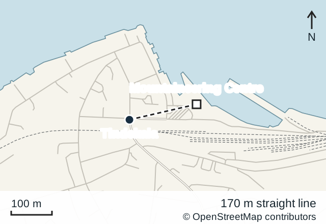
© OpenStreetMap contributors · Open in OpenStreetMap
Tindekaia is the main cruise quay, about 200 metres from the town centre according to the port factsheet. The port's 2026 cruise list assigns normal calls to Tindekaia and other named quays rather than anchorage, so access is classified as dock.
The central waterfront brings you close to the railway station and gondola area. For a berth at Tindekaia, there is normally no need for a shuttle into town. Follow the marked route out of the working quay and note the return entrance.
About this port
Åndalsnes sits where the Romsdalen valley reaches the fjord. Its compact centre makes an easy starting point, but the surrounding mountains shape most visitors' plans. A gondola offers a quick way up to a viewpoint; the Rauma railway follows the valley inland.
Choose one substantial activity for a short call. A train journey, mountain walk and Trollstigen road excursion each need their own time allowance. Trying to fit all three around a cruise departure leaves little room for weather, queues or transport changes.
Getting Around
Walk between the central attractions. For travel farther afield, compare the public train service with organised excursions and prearranged road transport. Use SJ Norge's Rauma line information for rail planning and FRAM for regional buses.
The Rauma line connects Åndalsnes with Dombås, passing through mountain and river scenery. Choose a journey only after checking the return departure and any service changes. A regular train ticket does not automatically include a guided sightseeing experience or extended photo stops.
Road excursions to Trollstigen depend on road conditions. Consult the Norwegian Scenic Routes information and confirm the route with your operator. Do not build a short independent visit around an assumed through-road opening.
Things to Do
Take the Romsdalen Gondola to Nesaksla. This is the most direct way to gain height above the town without a strenuous climb. The operator describes step-free access through the stations and a summit ramp, making it worth considering for passengers with limited mobility. Check the operator's current information for hours, tickets and access requirements.
Allow time to enjoy the outlook and to queue for the descent. Low cloud may hide the view, so inspect conditions before buying a ticket. The paths beyond the developed summit area are a separate hiking decision.
Ride into Romsdalen. The railway offers views of the valley, mountain walls and bridges. It suits passengers who want to see the landscape from a seat. Decide between a scheduled service and a dedicated sightseeing departure based on the complete excursion time, including the return to the quay.
Visit the Norwegian Mountaineering Centre. The centre introduces climbing history and the mountain environment through exhibits and activities. It is a useful town-based alternative when the weather makes a summit visit unattractive. Confirm the day's programme locally.
Consider Rampestreken with care. Reaching this viewpoint on foot involves a sustained climb; it is not a level promenade. Even taking the gondola up and walking towards it requires suitable footwear and enough time for the ascent back or descent into town. Choose the summit viewing area if you want a less demanding outing.
Getting back to your ship
The Rauma line connects Åndalsnes with Dombås, passing through mountain and river scenery. Choose a journey only after checking the return departure and any service changes. A regular train ticket does not automatically include a guided sightseeing experience or extended photo stops.
Practical Information
Use Norwegian kroner (NOK); cards are widely accepted. Norwegian is spoken locally and English is widely understood. Emergency numbers are 110 for fire, 112 for police and 113 for an ambulance.
Weather can differ between the waterfront and the mountain. Carry a warm waterproof layer and keep an easy town option in reserve. Check attraction hours and your return transport before setting out, and leave a margin before the ship's all-aboard time.
Frequently asked
Can you walk from Åndalsnes cruise port into town? Yes. Tindekaia is about 0.2 km from the town centre along the central waterfront.
How far is Åndalsnes station from the cruise quay? About 200 metres; the station and Norwegian Mountaineering Centre are in the central waterfront area.
Do cruise passengers need a shuttle in Åndalsnes? No. The port states that there is no shuttle and places the centre 200 metres from the pier.
Do cruise ships dock or tender in Åndalsnes? They normally dock. The port's 2026 cruise list assigns calls to Tindekaia and other named quays.
Sources
Sites consulted: cruise-norway.no, molde-romsdalhavn.no, romsdalen.no, sj.no, nasjonaleturistveger.no, frammr.no, visitnorway.com. Details can change after a guide is checked, so confirm time-sensitive points with the operator. How we check our guides.
Printed from https://portatlas.co.uk/europe/norway/andalsnes/. Guide check date appears above; consult the sources for time-sensitive details.